


It's April 30, 1960; Do You Know Where You Are?
posted by Pop Tart at
6:56 PM
![]()
![]()
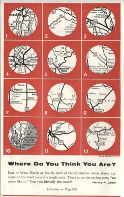
From The Saturday Evening Post, comes the double-dog-dare, "Where Do You Think You Are?"
7/16/08 Update -- With The Answers!
(complete with 1960 state abbreviations, for that full-bodied retro taste)
1. Mass
2. Colo
3. Mo.
4. Wis.
5. Idaho
6. N.J.
7. Iowa
8. Ariz.
9. Va.
10. Me.
11. S.C.
12. Wash.
Looks like Jason was right - congrats, map geek.
Second Place Steve was just 5 minutes off; story of his life, ey.


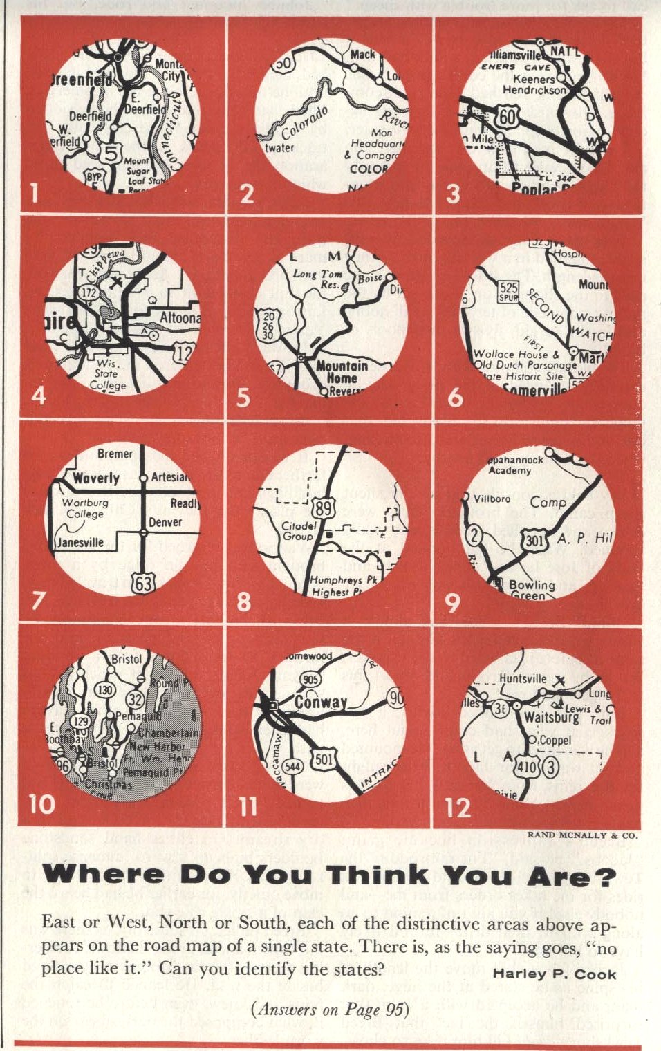
East or West, North or South, each of the distinctive areas above appears on the road map of a single state. There is, as the saying goes, "no place like it." Can you identify the states?Think you know your 1960's maps? (Or perhaps it is more accurate to say 1950's maps...) Maybe you're just a smarty pants. Whatever. Post your (however well-educated) guesses. I'll post the answers later in the week.
Harley P. Cook
7/16/08 Update -- With The Answers!
(complete with 1960 state abbreviations, for that full-bodied retro taste)
1. Mass
2. Colo
3. Mo.
4. Wis.
5. Idaho
6. N.J.
7. Iowa
8. Ariz.
9. Va.
10. Me.
11. S.C.
12. Wash.
Looks like Jason was right - congrats, map geek.
Second Place Steve was just 5 minutes off; story of his life, ey.
Labels: 1950s, 1960s, maps, quiz, vintage magazines


11 Comments:
Pfft- maps! They're so 50s and hard to follow! All Miss Janey can say is Thank goodness her crackberry has GPS.
I guess wisconsin, but that's an educated guess for now.
1 massachusetts
2 colorado
3 missouri
4 wisconsin
5 idaho
6 new jersey
7 iowa
8 arizona
9 virginia
10 maine
11 south carolina
12 washington
1
Deerfield, MA
Connecticut River is just to the East
2
Southwest of Mack and Loma CO
I-70 now sits between the river and Mack
3
Williamsville, MO close to Keener Cave
4
Eau Claire, WI
5
Just N of Mountain Home, ID
SE of Boise
6
Somerville NJ
7
Denver, Artesian, and Waverly, IA
8
West of Sunset Crater National Monument; Near Humphreys Peak and North of Flagstaff, AZ
9
Between Rappahannock Academy and Bowling Green, VA
Right in the middle of Fort AP Hill Military Reservation
10
On Rutherford Island on the West side of Johns Bay, ME
11
Conway, SC
12
Waitsburg, WA, which is right along the Lewis and Clark Trail
1 - MA
2 - CO
3 - AR
4 - MO
5 - ID
6 - NJ
7 - IA
8 - AZ
9 - VA
10 - ME
11 - SC
12 - WA
Without referring to Google:
2) Colorado
4) Wisconsin
5) Idaho
9) Virginia
With the assistance of Wikipedia and Google Maps:
1) Greenfield, Massachusetts
2) Colorado National Monument, Colorado
3) Poplar Bluff, Missouri
4) Altoona, Wisconsin
5) Mountain Home, Idaho
6) Somerville, New Jersey
7) Waverly, Iowa
8) Humphreys Peak, Arizona
9) Bowling Green, Virginia
10) Pemaquid Point Light Station, Maine
11) Conway, South Carolina
12) Waitsburg, Oregon
"Each of the distinctive areas above appears on the road map of a single state."
Why can't people in this country read anymore????
It's Iowa. I know because I live there (here), and I have been to most of these places.
It's either Alabama or Georgia
Anon (#1, anyway), it also says, "Can you identify the states" -- with an 's'...
wahoo!
Thanks google + google maps :)
Post a Comment
Links to this post:
Create a Link
<< Home